Chapter 17: Water Quality and Conservation
Chapter Contents:
Water is a priceless limited resource and should be treated as such. The earth’s population continues to grow rapidly, and as weather patterns and climate continue to change, there is increased demand for and stress on water supplies. Water shortages are becoming more frequent and severe, and water use restrictions are now permanent in many parts of the world and across the United States. Regulations governing water quality protection and water quantity conservation are more numerous and stringent than ever before. For these reasons, it is everyone’s responsibility to be a good steward of this essential, invaluable and finite resource.
Watersheds
What Is a Watershed?
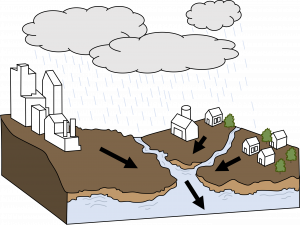
A watershed is an area of land that drains to a lake, river, wetland, or other waterway. When precipitation occurs, water travels over forest, agricultural, or urban/suburban land areas before entering a waterway. Water can also travel into underground aquifers on its way to larger bodies of water. Together, land and water make up a watershed system. Watersheds can be any size. For example, the Chesapeake Bay Watershed drains upstream land from a 64,000 square mile area in six states. Local watersheds drain much smaller areas, perhaps only a few acres in size.
Virginia Watersheds
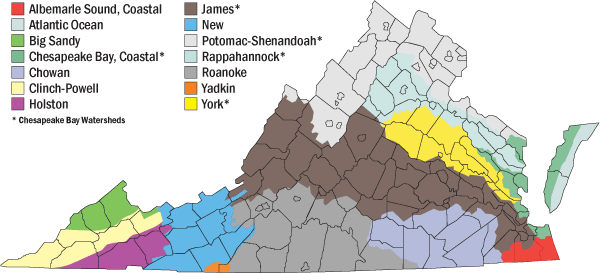
Everyone lives in a watershed, and Virginia has nine major watersheds with numerous sub-watersheds. Virginia’s watersheds ultimately drain into three main bodies of water. Nearly two-thirds of Virginia drains into the Chesapeake Bay. Southeastern and south-central Virginia drain into the Albemarle Sound in North Carolina. Rivers in Southwest Virginia flow to the Mississippi River and then to the Gulf of Mexico.
Why Are Watersheds Important?
Healthy watersheds are a vital component of a healthy environment. Watersheds act as a filter for runoff that occurs from precipitation and snowmelt, providing clean water for drinking, irrigation, and industry. Recreation and leisure are important components of watersheds, with many possibilities in Virginia for boating, fishing, and swimming. Watersheds also support a variety of plant and wildlife communities. Scientists and community leaders recognize the best way to protect our water resources is to understand and manage them on a watershed basis. Human activities as well as natural events that occur in a watershed can significantly affect water quality and quantity.
Water Cycle
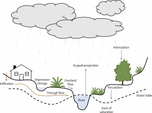
Earth’s water is always cycling; constantly moving and changing states between liquid, vapor, and ice. The water cycle, also known as the hydrologic cycle, describes the continuous movement of water on, above, and below the surface of the Earth. Development negatively impacts the water cycle by 1) stripping plant cover, and 2) replacing it with impervious surfaces (roofs, roads and parking lots) that prevent infiltration of precipitation. The result is the generation of high volumes of runoff from urban development that causes erosion and flooding downstream.
Surface, Ground, and Storm Waters
Surface, ground, and storm waters are often viewed and treated as separate entities, but they are part of an interconnected system where each impacts the other and humans impact them all. Depletion of surface and ground water sources is caused by over-use. Flooding, erosion and reduced groundwater recharge are caused by development (impervious surfaces). Water pollution is caused by carelessness, irresponsible behavior, and a lack of understanding that water is a finite resource critical to our survival.
Surface Water
Surface water is water on the earth’s surface or that has not penetrated much below the ground such as in a stream, river, lake, wetland, reservoir, stormwater pond, or ocean.
Surface water is replenished by precipitation, and is lost through evaporation, infiltration into the ground where it becomes ground water, and use by plants or by man.
Groundwater
Groundwater is water located beneath earth’s surface, held underground in the soil and in pores and crevices in rock (aquifer).
Wells are holes or shafts sunk into the earth to obtain water. One in five Virginians, or nearly 1.7 million people, rely on private water supplies such as wells, springs, and cisterns for their household water (Virginia Cooperative Extension 2015). In the U.S., all water systems (with the exception of a few private wells) are regulated under the Safe Drinking Water Act, which requires routine water testing and treatment. However, people with private water supplies are responsible for all aspects of system management, including water testing, interpreting test results, and addressing problems. Through the Virginia Household Water Quality Program, Virginia Cooperative Extension provides access to affordable and confidential water testing, interpretation of results, and education about system care and dealing with problems. Testing includes total coliform and E. coli bacteria, nitrate, lead, copper, arsenic, pH, hardness, sulfate, fluoride, iron, manganese, sodium, and total dissolved solids. For more information about the Virginia Household Water Quality Program and wells and springs in Virginia, visit the Biological Systems Engineering well water testing website.
Stormwater
Stormwater is water that originates during precipitation events and snow/ice melt. Stormwater can soak into the soil (infiltrate), be held on the surface and evaporate, or run off into surface water bodies. Storm events are measured by their duration, depth, and intensity.
- Duration (hours): Length of time over which rainfall (storm event) occurs.
- Depth (inches): Total amount of rainfall occurring during the storm duration.
- Intensity (inches per hour): Depth divided by the duration.
Infiltration allows the stormwater to be filtered and eventually will flow into streams and rivers or help to replenish aquifers. The more frequent and intense storms and flooding events caused by our changing climate increases stormwater runoff. Increased stormwater runoff can cause new pollution problems or make existing pollution problems worse. This runoff can increase levels of sediments, nutrients, and other pollutants in local waterways, causing water quality challenges.
These intense rainfall and flooding events can overwhelm stormwater management systems put in place by municipalities. These municipal systems can get backed up and cause localized flooding or increased runoff of contaminants into local waterways. Cities may also see challenges with their wastewater drainage systems, which can be overwhelmed by large rain events and lead to sewer overflows into waterways.
Urban watersheds face additional challenges due to the impact that development has on how water travels and increased impervious surfaces throughout these areas. Urban areas will most commonly have reduced infiltration of water to the soil and a higher runoff volume. Urban municipalities install management systems to help provide efficient drainage and prevent damage to public and private property, streets, streams, and other waterways.
Water Pollution
Pollution can refer to either contaminants themselves or to the act of contaminating water bodies (surface and ground) when pollutants are discharged (directly or indirectly) into them without treatment to remove harmful compounds.
Pollutants include:
- Nutrients (primarily nitrogen and phosphorus)
- Sediment
- Pathogens (disease causing microorganisms)
- Petroleum products and fuel
- Detergents and solvents
- Pharmaceuticals
- Heavy metals
- Pesticides
- Manufacturing and industrial waste
- Sewage and fecal matter
- Leaves, trash and other debris
Water pollution affects the entire ecosystem. The effect can be acute (one time immediate effect) or cumulative (building up over time). Sometimes the pollution can be cleaned up or inactivated quickly, but most of the time the recovery process is lengthy.
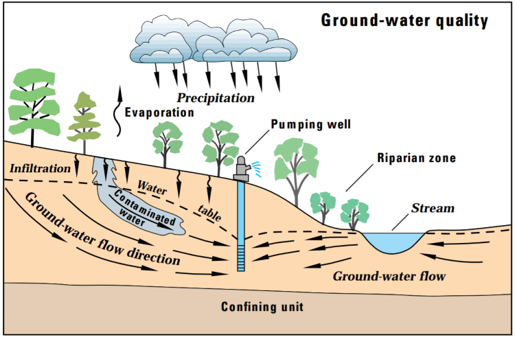
Groundwater and surface water are interconnected parts of the water cycle and both can be contaminated through a variety of mechanisms. When precipitation falls, part of that water is absorbed by plant canopies, part evaporates, part runs off into surface water bodies, and part soaks into the ground. Water that soaks into the ground is held in the soil, taken up by plants or it infiltrates deeper into the soil. The water that reaches the saturated zone (water table) is known as recharge water, and it is needed to resupply groundwater that is continually being brought to the surface through natural springs, wells, plant use, and other means. Pollutants flow with the water either horizontally on the surface or vertically into the ground. When water infiltrates the soil and carries a pollutant with it, it’s called leaching.
Water Contamination Mechanisms
- Pollutants in the air fall to the ground with precipitation (atmospheric deposition)
- A pollutant is deliberately discharged into the water
- A pollutant is accidentally discharged into the water
- A pollutant is moved by runoff
- A pollutant attaches to sediment which is then moved by runoff
- Surface water leaches a pollutant into the groundwater
- Contaminated groundwater is pumped into a surface water body
Water Pollution Categories
Point source pollution comes from a single source, typically a spill, a discharge pipe, or an illegal dump of chemicals.
Nonpoint source pollution comes from a large land area, not from one specific location or source; typically from daily and land use activities, collected and concentrated through runoff
Water quality programs, which include both regulatory, voluntary and grant programs, have significantly reduced point source pollution in the United States. Because non-point source pollution is wide spread and is the result of many different activities, it is much more difficult to regulate and reduce.
Examples of Pollution Include:
- Accumulation of sediment from erosion flowing into the Chesapeake Bay, destroying submerged aquatic vegetation and associated habitat, which then can lead to “dead zones” from lack of oxygen in the water.
- Excess fertilizer in runoff from landscapes creating algae blooms in stormwater retention ponds.
- Raking or blowing leaves or dumping chemicals into a storm drain.
- A pesticide gets into a surface water body and kills fish as a result of not following label directions.
- A pesticide tank accidentally overturns and pesticides leach through the soil and contaminate groundwater.
- Dog waste that is not “scooped” up washes into the water and swimming areas are closed because of high levels of pathogens
Persistence and solubility determine the contamination potential of a chemical.
Persistence
Persistence is the amount of time a chemical remains active before it is degraded or broken down into harmless components. Persistence is measured in a “half-life” which is the amount of time it takes for one-half the original amount of a chemical to be degraded. Chemicals that have a long half-life remain active for a longer periods of time.
Solubility
The ease with which a chemical dissolves and mixes with water is called solubility.
A chemical with a long half-life and high solubility would have the greatest potential for water contamination. Conversely, a chemical with a short half-life and low solubility would not be chemically active as long and would have a reduced risk of water contamination.
Contaminants are inactivated in many ways. They can be diluted by surface water until they are below a harmful level. They can be broken down into harmless components by sunlight (photodecomposition) or by microorganisms (biological degradation) or through chemical reactions (natural or manmade). Contaminants can change form through volatilization and move into the atmosphere. Finally, they can be absorbed into the plant where they are used, broken down or stored, or they can attach to soil particles or organic matter (adsorption).
Water Quality Standards
Water quality can be evaluated using many standards, including: color, odor, dissolved oxygen content, nutrient levels, aquatic life, pathogens, turbidity, salinity, pH, chlorophyll, sediment, and many more. Standards are used to assess water quality for purposes such as drinking, swimming, irrigation, wildlife and aquatic life health, and food safety (fish and shellfish). Water quality in undisturbed healthy ecosystems is measured and documented using different standards, then water quality in disturbed ecosystems is measured and compared. Standards provide the basis for the regulations governing water quality and the measure of water quality improvement or decline over time.
The Virginia Department of Environmental Quality (DEQ) extensively tests Virginia’s rivers, lakes and tidal waters for pollutants. More than 130 pollutants are monitored annually to determine whether the waters can be used for swimming, fishing and drinking. Waters that do not meet standards are reported to the citizens of Virginia and the U.S. Environmental Protection Agency in the Virginia Water Quality Assessment 305(b)/303(d) Integrated Report.
DEQ has developed a list of impaired waters since 1992 that includes segments of streams, lakes and estuaries that exhibit violations of water quality standards. The report details the pollutant responsible for the violations, and the suspected cause and source of the pollutant. Since 1998, DEQ has developed plans, with public input, to restore and maintain the water quality for the impaired waters. Within these plans are “total maximum daily loads,” or TMDLs. TMDL is a term that represents the total pollutant a water body can assimilate and still meet standards. For example, the Chesapeake Bay TMDL is based on nutrient (nitrogen and phosphorus) and sediment standards.
Water Conservation and Protection
How can residential landscapes be smartly designed and used for water conservation and protection? How can small simple practices by individuals have a significant and positive impact on water quality? How can we ensure the state’s surface and ground water resources are high quality and plentiful and still have attractive lawns and landscapes? The answer is a balance between awareness and action. First there has to be an understanding of the value of water, how the water cycle works, and that water is everyone’s business. Then everyone has to do something. Collectively, many small actions by individuals lead to powerful results. There are really only two main water quality issues to focus on:
- Water misuse and waste
- Stormwater management
Statistics
- The average American family uses 320 gallons of water per day
- About 30% of those 320 gallons is devoted to outdoor uses
- More than 50% of that outdoor water is used for watering lawns and gardens
- As much as 50% of water used for irrigation is wasted due to evaporation, wind, or runoff caused by inefficient irrigation methods and systems
Source: WaterSense program, EPA
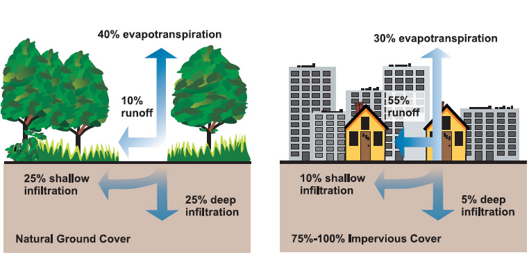
Virginia’s average annual rainfall is 38-49 inches depending on the city and region (coastal, piedmont or mountain) of the state (National Centers for Environmental Education, 2022). While the rainfall is generally distributed fairly evenly throughout the year, distinct wet and dry periods do occur. Storm events are increasing in magnitude and dry periods are becoming longer, possibly due to climate change. With human population comes development and associated impervious surfaces, which replaces the natural vegetation and soil filtering system of the watershed. More development generates more runoff. When water runs across impervious surfaces, pollutants (from the list above) are collected and carried into storm drains. Runoff water does not go to a treatment facility; instead, storm drains deliver the polluted water directly into waterways and water bodies. Runoff is the biggest contributor to non-point source pollution. The three important runoff components to manage are: volume, velocity or flow rate, and pollutants.
State Regulatory Information
Virginia is in EPA Region 3 (Mid-Atlantic) which also includes Delaware, District of Columbia, Maryland, Pennsylvania, and West Virginia.
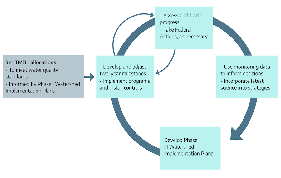
Chesapeake Bay Total Maximum Daily Load (TMDL): TMDL is a historic and comprehensive “pollution diet” that involves all the states in EPA Region 3 plus a part of New York state. A TMDL is used to determine the maximum amount of pollution a water body can assimilate without violating water quality standards. The Bay TMDL includes pollution from permitted point sources (waste water), and nonpoint and natural sources (landscapes, wildlife, etc.). The TMDL, the largest ever developed by EPA (encompassing a 64,000-square-mile watershed), identifies the necessary pollution reductions from major sources of nitrogen, phosphorus and sediment. The TMDL was established in 2010 with rigorous accountability measures to initiate sweeping actions to restore clean water in the Chesapeake Bay and the region’s streams, creeks and rivers. It is based on watershed implementation plans (WIPs) for reducing pollution going into the bay prepared by the 6 states and the District of Columbia; submitted to and approved by EPA. Specifically, the TMDL sets Bay watershed limits of 185.9 million pounds of nitrogen, 12.5 million pounds of phosphorus and 6.45 billion pounds of sediment per year – a 25% reduction in nitrogen, 24% reduction in phosphorus and 20% reduction in sediment. In 2012, the jurisdictions submitted Phase II implementation plans designed to strengthen the initial cleanup strategies and reflect the involvement of local partners. They also submitted a set of two-year milestones outlining near-term restoration commitments. The Bay TMDL is a key part of an accountability framework to ensure that all pollution control measures needed to fully restore the Bay and its tidal rivers are in place by 2025, with practices in place by 2017 to meet 60% of the necessary pollution reductions. For more information, visit the EPA’s Chesapeake Bay TMDL website.
State Water Control Board: The board is one of three regulatory boards (Air Pollution Control Board, State Water Control Board and Waste Management Board) that is composed of Virginia citizens appointed by the Governor. The board is responsible for adopting many of Virginia’s environmental regulations including state mandates on water quality in the Clean Water Act and the Code of Virginia. The board reports to the Virginia General Assembly.
The State Water Control Law (Code of Virginia): The law requires the Board to establish standards of water quality and to modify, amend or cancel any such standards or policies every three years. It also requires the Board to hold public hearings periodically for the purpose of reviewing the water quality standards. The Virginia State Water Control Law incorporates the Chesapeake Bay Preservation Act, Erosion and Sediment Control Law, Virginia Stormwater Management Act, and General Permit for Discharges of Stormwater from Construction Activities.
Virginia Antidegradation Policy: Virginia’s antidegradation policy protects water quality at three levels or “tiers.” Tier 1 specifies that existing instream water uses and the level of water quality to protect the existing uses shall be maintained and protected. This means that, as a minimum, all waters should meet adopted water quality standards. Tier 2 protects water that is better than specified water quality standards. Only in limited circumstances may water quality be lowered in these waters. Tier 3 are exceptional waters where no new, additional or increased discharge of sewage, industrial wastes or other pollution are allowed. These waters must be specifically listed in the regulation.
Virginia Water Quality Standards: These standards are part of the State Water Control Law. They consist of statements that describe water quality requirements. They also contain numeric limits for specific physical, chemical, biological or radiological characteristics of water. These statements and numeric limits describe water quality necessary to meet and maintain uses such as swimming and other water-based recreation, public water supply, and the propagation and growth of aquatic life. Standards include general and specific descriptions, because not all requirements for water quality protection can be quantified or numerically defined. The standards are adjusted constantly to reflect changes in law, technology and information available to the Water Board and DEQ.
Virginia Department of Environmental Quality (DEQ): DEQ administers Virginia’s laws and the regulations approved by the State Water Control Board through two Divisions (Water Permitting and Water Planning) with the goals of improving and protecting Virginia’s streams, rivers, bays, wetlands and ground water for aquatic life, human health and other beneficial water uses.
Water-Wise Landscaping
Start with a site analysis. Then use that information to develop a management plan which incorporates water conserving and protection best management practices (BMPs) that meet the site and user goals and that conserve and protect water resources. The plan can be set up as a one year monthly check or reminder list. It can also include long term planning. For example: researching and selecting trees is done in the spring or summer and purchasing and planting in the fall when they are dormant and do not need as much irrigation to get established; the driveway is badly cracked, so it will be replaced with permeable pavers in 2 years.
Calculate the size of the property. Multiply the length x width to get the total square feet. Then add up the square feet of all the impervious surfaces (roofs of the house and outbuildings, driveway, sidewalks, patio, etc.). Rainfall runs off of these surfaces. Divide the impervious surface number by the property size to get the percent (%) of the property that generates runoff. This calculation assumes that there is 100 % runoff from the impervious surfaces. There is no right or wrong answer, but the higher the %, the more important water management is for the property.
Example:
Property size: 80’ x 136’ = 10,880 square feet (about 1/4 acre)
Impervious surfaces:
- House roof 60’ x 80’ = 4,800 square feet
- Driveway 12’ x 50’ = 600 square feet
- Patio 15’ x 20’ = 300 square feet
- Sidewalks 3’ x 50’ = 150 square feet
Total = 5,850 square feet
5,850 square feet / 10,880 square feet = 54% impervious
In this example, rainfall runs off of over half of the property. If 45 inches of rain fell in one year, that would be 84,997 thousand gallons of runoff; enough to fill 1,214 standard bathtubs! The U.S. Geological Survey has a rainfall calculator here.
Conduct a water quality site analysis. Use the chart on the site analysis form at the end of the chapter to evaluate the landscape practices that impact water quality. This information might come from landscape design documents or a walk around the property. Put a check in the plus column if the practice is existing or being done and a check in the minus column if it is not. Use the comments section to note whether a practice in the plus column could be improved. As with the % impervious number, there is no right or wrong answer. This chart is simply a tool to evaluate what practices could be done better or added to the landscape to improve water management.
Runoff calculation tool: The U.S. Environmental Protection Agency has an advanced stormwater calculator here that allows you to enter information about your site and generate estimated yearly runoff, maximum runoff, and more.
Irrigation
Irrigation is the application of water to land. Irrigation systems can be expensive to install and require maintenance. Remember to call MISS UTILITY at 811 before digging to install a system. Take the time to design an efficient adaptable system based on the landscape design, user lifestyle and vegetation.
Overhead irrigation
- Also called high flow, spray or sprinkler irrigation
- Can include rigid pipe, fixed risers, irrigation heads (spray, rotor, and impact)
- Applies water over top of plants simulating rainfall
- Uses a higher volume of water than drip irrigation
- Has a higher potential than drip irrigation for waste from runoff and evaporation
- Problems include: broken line or heads, uneven coverage,
- Can be operated by a controller
- Needs to be checked periodically for problems
Drip irrigation
- Also called low flow or volume, micro, and trickle irrigation
- Can include soaker hoses, flexible tubing, drip lines or emitters, micro spray
- Applies water to the plant root zone with less volume, evaporation, and runoff
- Problems include: clogged emitters, lines chewed by wildlife, may require a pressure reducer and filter, tripping hazard
- Can be operated by a controller
- Needs to be checked regularly for problems
How to calibrate an overhead irrigation system
- Use 4-6 rain gauges or straight-sided cans (soup, coffee). If using cans, make sure all are the same shape and size.
- Place the rain gauges or cans in a scattered pattern in the area being irrigated
- Run the irrigation system for 15 minutes
- Measure the amount of water in each gauge or can to the nearest 1/8-inch
- If the amounts in each container are NOT close to the same amount, check for leaks and adjust the spray heads for more even coverage. Repeat steps above.
- If the amounts in each container are close to the same amount, then add the amounts together and divide by the number of containers to get the average depth of water collected.
- Multiply the average depth of water times four to determine the irrigation rate in inches per hour.
- Use the chart to determine the amount of time to run the irrigation system to apply the desired amount of water
Table 17-1: Time in minutes required to apply water at a given irrigation rate
| Inches of water applied | 0.5” inches of water applied/hour | 1”inches of water applied/hour | 1.5” inches of water applied/hour | 2”inches of water applied/hour |
|---|---|---|---|---|
| 0.5” | 60 minutes | 30 minutes | 20 minutes | 15 minutes |
| 0.75” | 90 minutes | 45 minutes | 30 minutes | 23 minutes |
| 1” | 120 minutes | 60 minutes | 40 minutes | 30 minutes |
If runoff occurs before the irrigation cycle is finished, then the timer should be reset for a split application: irrigate for half the time, wait 2-4 hours then irrigate the rest of the time remaining. Do this in the morning before daytime temperatures and sunlight cause evaporation.
Stormwater Best Management Practices (BMPs)
Stormwater BMPs can be used individually or connected together to manage runoff. For example, a downspout can be disconnected from the storm drain so that it runs into a rain barrel or into swale which then connects to a rain garden. A combination of BMPs is frequently used to manage water quality on a site. They can be designed as part of the site development or retrofitted into the site over time.
Remember, the three important runoff components to manage are: volume, velocity, and pollutants. Reduce the volume, slow the velocity, and remove the pollutants.
Healthy Soil
A healthy soil acts like a sponge and filter; soaking up stormwater and filtering it as it infiltrates and percolates through the layers into the ground water. Soil texture, organic matter content and pH all affect the movement of pollutants through the soil. Water infiltrates sandy soils quickly and clay soils more slowly. Water should not stand for more than 4 days after a storm, ideally 2 days or less as mosquitos can go from egg to adult in standing water at 7 days. Aeration and incorporation or spreading organic matter on top of the soil (especially in lawn areas) will improve drainage. Soils with a higher organic matter content filter pollutants more effectively. Organic matter promotes healthy microbial populations, which break down pollutants, and many pollutants will adsorb to organic matter particles and become inactivated. Organic matter also provides nutrients to plants which means less fertilizer is needed. A soil test should be done every 3 years to make sure there are adequate nutrients available for plants and to prevent over fertilization. Soil pH can affect the movement of chemicals, especially fertilizers, through the soil by influencing their availability to plants. In very acidic or very alkaline soils, some nutrients can become unavailable to plants and then may be leached into the ground water. Bare areas should be covered with mulch or vegetation to prevent erosion. Steep slopes should be planted or terraced to prevent erosion. A healthy soil grows healthy plants, which require fewer nutrients and less pest management thus reducing the potential for pollution from fertilizers and pesticides.
Healthy Plants
Select plants that are adapted to the site and environmental conditions and plant them correctly, so the roots establish quickly and they require less or no irrigation (after establishment). Use pest resistant plants and scout regularly to catch any pest problems early. Use cultural, biological or mechanical control methods and the least toxic insecticides and fungicides to treat when necessary. This is integrated pest management (IPM), and it significantly reduces the amount of chemicals used and thus the potential for water pollution from them. When pesticides (insecticides, fungicides, herbicides) are necessary, use the product least toxic to the applicator and environment. Read the entire label and follow application instructions carefully. Do not apply pesticides right before an irrigation cycle or rain event as they usually need time to dry. If they wash off, they could have off-target effects on other parts of the landscape or the aquatic ecosystem. Plants should be grouped by their water needs (hydrozones) so that irrigation is used only where necessary and efficiently. For example, impatiens should not be planted next to cactus. Use large trees, understory trees, shrubs and lower growing plants to create canopy layers. Canopies intercept rainfall, absorbing some of it and slowing the rest down so it is more likely to soak in than run off when it reaches the ground. Use a mulching mower and leave the grass clippings on the lawn. This is a free and natural source of nutrients and organic matter which keeps the grass healthier and reduces the need for fertilizer. Mowing the lawn at the correct height keeps the grass from thinning, which prevents weeds and reduces the need for herbicides. A healthy dense lawn reduces runoff and erosion.
Nutrient Management
Runoff
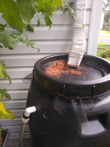
Rain Barrels
From the Rooftops to the Roots – An Integrated Approach to Harvesting Rain Water
By Shawn Jadrnicek, Extension Agent, Virginia Cooperative Extension, Roanoke
Rain barrel water rarely finds its way into the landscape. After collecting all those drops of precious rain, the barrels often stand idle like industrial ornaments in the yard. Their slow flow of gravity-fed trickling water combined with the expense and complexity of installing a pump, filter, and irrigation system, prevents rain barrels from following through with their intended purpose. We encountered this problem at a farm where a 1,500-gallon tank was installed without provisions for using the stored water. During every rain event, the full tank would overflow and wash out an adjacent gravel road.
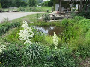
To solve the problem, we connected the tank to a water garden pond positioned on the south side of the building. The pond was strategically located to reflect sunlight into the adjacent building in the winter, but not in the summer. Since water gardens lose a lot of water to evaporation, we attached a flexible and inexpensive one-half inch poly line to the tank drain and used a float valve to connect the line to the pond. Float valves are similar to the valves in your toilet — the flushing lowers the water level and the float valve engages to refill the tank. As water evaporated from the pond, the float valve allowed gravity to push water from the tank into the pond. A much cheaper method than refilling with city water to keep the water garden full.
Once the water flowed from the tank into the pond, it was used and stored as needed. We placed soil on top of the pond liner, which not only protected the liner but also wicked water out of the pond. The constant wicking action, like an oil candle wick pulling oil out of a vase, drew water out of the pond to irrigate nearby plants. We also drained water from the pond into adjacent rain gardens. Just opening the drain during dry times helped irrigate the rain garden plants. Finally, we rerouted any overflow back into the pond. Rather than an overflowing tank washing gravel away, our new system allowed the tank to overflow into the pond and the pond to overflow into the rain gardens.
Because the pond created various microclimates, we added edible plants such as Tradescantia virginiana, Apios Americana, Yucca filamentosa, Sagittaria sagittifolia and Opuntia ellisiana and ornamentals such as Iris virginiana around its edge. The fish-free pond sustained a wide variety of amphibians which wandered out into the landscape to eat pests and entertained us late into the night with their harmonious symphony.
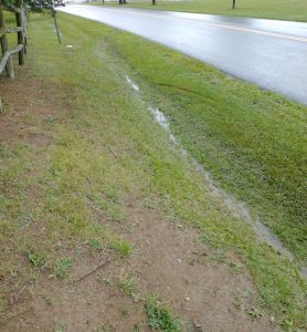
A swale is a shallow and wide channel that moves water slowly from point A to point B allowing it to infiltrate or evaporate along the way, unlike a ditch; which is narrow and deep and moves water quickly from point A to point B. Swales are generally less than 12 inches deep and have vegetation growing in them. They require permeable soil, little space, grading for water flow, and maintenance to keep the vegetative cover dense and trash and debris cleaned out. Swales act like shock absorbers by reducing the initial volume and velocity of runoff flow. See the following VCE publications for more on swales: “Best Management Practice Fact Sheet 11: Wet Swale” “Best Management Practice Fact Sheet 10: Dry Swale” and “Stormwater Management for Homeowners Fact Sheet 4: Grass Swales“
Rain Gardens
A rain garden (bioretention) is a shallow landscaped depression that filters polluted stormwater before it evaporates, evapo-transpires through the plants, or percolates through the soil into the groundwater. Basically, imagine a landscaped puddle. A rain garden has three planting zones (high, middle, and low), with low being wettest the longest. Runoff should move out of the rain garden within four days. If drainage is poor, then aeration or an underdrain or dry well can be used to improve water infiltration. At least 5% of the impervious area should drain into the rain garden to make it worth doing cost and labor wise. The depth of a rain garden is approximately 6 inches. Usually they are dug and graded deeper, 12-24 inches, because organic matter is added, plant root balls displace soil, and mulch is added to the top; which all raise the level. The gardens can be placed at any point along the runoff pathway. One large rain garden or several small ones connected together can be used depending on the available space and landscape design. Always plan for an overflow event. Many rain garden plant lists recommend using natives. Plants should be spaced so that the canopies touch and provide a solid cover to prevent weeds. They generally establish quickly and need to be divided about every 3 years. Mulch should be added sparingly after the establishment period, because adding it every year will raise the level and the garden will not hold enough water to be effective. After establishment, maintenance is minimal and mainly involves removing invasive weeds, tree seedlings, trash, and debris. The most comprehensive resource for residential or small-scale rain gardens in Virginia is the Rain Gardens Technical Guide from the Virginia Department of Forestry. Larger rain gardens that are used for commercial sites are typically engineered and often include underdrains if underlying soils have low infiltration rates. These larger rain gardens are known as “bioretention systems.”
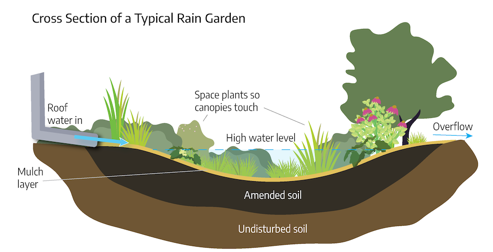
What size should the rain garden be?
To calculate the area needed for a rain garden, divide the number of square feet of impervious surface draining into it by 20. (This calculation assumes all surfaces are 100% impervious)
Buffer Zones
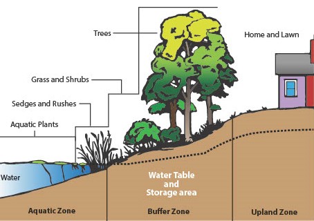
A buffer zone (riparian buffer) is an area of vegetation adjacent to a body of water. It functions similar to a rain garden with high, medium, and low planting zones.
Buffers:
- Slow down and spread out runoff
- Filter sediment, nutrients, and pollutants
- Stabilize the shoreline and prevent erosion
- Provide food and habitat for wildlife
- Add visual and species diversity
- Help moderate flooding
Buffer zones are unique for each location, and can be formally landscaped, naturalized, or anywhere in between. Buffer width can range from as little as 5 feet to over 100 feet. No formal design is required. They can be easily created in residential or commercial landscapes along fresh or brackish/salt water. A combination of woody and herbaceous plants is recommended. Most buffer zones are low maintenance. Buffer zones have the biggest impact on improving water quality for the least amount of money, effort, and long term maintenance.
Rooftop or Downspout Disconnect
Rooftop or downspout disconnect and rain chains are practices that slow runoff velocity. Sometimes downspouts connect directly into a pipe that runs into the storm drain. Disconnecting the downspout from the pipe and redirecting the runoff into a swale, a rain garden or into the landscape treats pollutants at the beginning of the runoff pathway and prevents erosion and stream blow out from high volumes and velocities of runoff. In some cases, rain chains can be used in addition to or instead of down spouts. They slow the velocity of the runoff and can be connected from the gutter to a swale, a rain barrel or a rain garden. These practices can be used on any residential or small commercial building as long as the site can handle the volume of runoff and it is directed away from the building foundation. Rain chains and extension pipes for downspouts are inexpensive. Maintenance involves keeping the gutters clear of debris to prevent clogging the downspout or rain chain.
Permeable Paving
Permeable paving includes pervious concrete, porous asphalt and interlocking concrete pavers. Stormwater infiltrates into pores in the concrete and asphalt or into joints between the pavers instead of running off. These products are most suited for low-traffic-load and parking areas, and for pedestrian traffic areas. They are also used on certain highways to prevent hydroplaning. These pavements consist of several layers, including the pervious top layer and underlying layers of gravel or stone that create a stormwater storage reservoir. The pavement depth and materials are determined by the amount of runoff storage needed and by amount of traffic. Permeable pavements provide stormwater management through temporary storage of runoff which then infiltrates or through an underdrain (necessary if soil is not permeable), and discharges to a stormwater drain. Permeable paving can remove sediments, nutrients, and some metals; however, sediment clogs the pores of these systems. Periodic vacuuming of the surface is necessary to remove sediments and keep the system functioning. These systems can be expensive.
Stormwater Ponds
Stormwater ponds can be either wet (retention) or dry (detention). Runoff comes into the pond through storm drains and culverts. This interrupts the runoff pathway which slows the velocity and reduces the volume of runoff from impervious surfaces flowing into natural waterways. The water is stored temporarily while pollutants are removed through settling and biological uptake. Sediments settle to the bottom and vegetation and aquatic organisms filter or break down pollutants over time. A wet pond holds water all the time. When a storm happens, polluted runoff comes into the pond and pushes the clean water out of the pond through an outflow or overflow pipe into natural waterways. Because they retain water for a longer time, wet ponds typically are able to remove more pollutants. Wet ponds should have buffers around the perimeter to stabilize the bank, prevent erosion, and filter runoff coming over land instead of through pipes. The average life expectancy for a wet pond is 15-20 years before it needs to be dredged out so it will continue to hold the desired volume of runoff and not cause flooding.
Dredging is very expensive (approximately $100,000 per quarter acre based on the amount of sediment removed, disposal costs, and permits/fees). Maintaining a buffer around the pond to prevent bank erosion and keeping trash and debris out of the storm drains and the pond extend the life of the pond. A dry pond is designed to hold water for a short period of time before allowing the water to discharge to a nearby stream. Between rain events, a dry pond looks like a large, grassy low area. When it rains, the pond fills with water and holds it for 48-72 hours to allow sediment and pollutants to settle out. Because they detain water for a brief time before allowing it to flow out, dry ponds are also called detention ponds. Dry ponds are generally more common, less expensive to install, require less maintenance and may involve less liability for the communities around them. However, they are also the least efficient pond for removal of pollutants. Most stormwater ponds are on commercial or municipal property or are in community “common areas” that are maintained by homeowner associations, civic leagues or property management companies.
Green Roofs
Green roofs (living or vegetated roofs) slow and filter stormwater on top of buildings at the very beginning of the runoff pathway. The system components include plants, a light weight growing media, drainage layer, and a waterproof liner to cover the roof structure. It is much easier to design a green roof for a new building than to retrofit an existing building because of the weight load. In addition to stormwater management, green roofs insulate the building, extend the roof life, and lower urban air temperatures. Green roofs are either intensive (thicker and heavier, supporting a wider variety of plants and requiring more maintenance) or extensive (shallow, lighter, and requiring minimal maintenance). There are many green roof designs and systems available. Periodic irrigation and invasive plant removal is required for all of them.
Floating Treatment Wetlands
Floating treatment wetlands (FTWs) are manmade ecosystems that mimic natural wetlands. FTWs are created using floating rafts that support plants grown hydroponically. The rafts float on a wet pond water surface and are either anchored to the bottom or the shore. They improve water quality by filtering, consuming, or breaking down pollutants from the water. FTWs should be located adjacent to the shoreline or where inflow pipes deliver polluted runoff into the pond so they will intercept the most polluted runoff. FTWs located near the shoreline also attenuate wave action and reduce undercutting and bank/shoreline erosion. Designs are available for making FTWs or manufactured ones can be purchased. Cost ranges from $1-$24 per square foot.
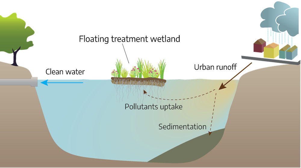
Advantages of FTWs include:
- Can be sized to fit into almost any pond or lake
- Enhance the pollutant-removal effectiveness of existing stormwater wet ponds
- Provides a sustainable pollutant-removal system and wildlife habitat
- Can tolerate water-level fluctuations, and improves aesthetics
FTW maintenance includes:
- Removing invasive plants
- Keeping the anchoring system secure
- Harvesting the vegetation for maximum nutrient removal rates
Storm Drain Protection
Storm drain protection/cleaning is a simple but effective runoff management practice. A storm drain is a system to carry runoff from impervious surfaces such as streets, parking lots, sidewalks, and roofs to a stormwater pond or natural water body. Do not rake or blow grass clippings or leaves into a storm drain or dump oil or any other chemicals down it. Keep branches, trash and other debris out of it. If the drain gets clogged, it will cause flooding. When a drain is in the landscape, plant low growing evergreen plants around it to slow and filter runoff before it goes into the drain. The plants also keep trash, grass clippings and mulch from washing into the drain.
Subsurface Drainage
Subsurface drainage might be needed if runoff does not drain through soils in a timely manner. This type of drainage is sometimes used underneath rain gardens. The 2 most common types of subsurface drainage are French drains (under drain, drain tile) and dry wells. A French drain is a trench filled with gravel or containing a perforated pipe that redirects surface water and groundwater away from an area. French drains are primarily used to prevent ground and surface water from penetrating or damaging building foundations. They can also be used to distribute water, such as a septic drain field or behind retaining walls to relieve ground water pressure. A dry well (infiltration basin) is an underground structure that collects runoff and allows it to seep into the ground to recharge groundwater. Water flows into a dry well either through gravity or pipes. Dry wells can be manufactured devices with perforated sides and bottom or a pit filled with gravel or rock covered by landscape fabric to prevent sediment from clogging the pores. Dry wells are usually buried completely, so that they do not take up any land area. For example, the dry wells for a parking lot’s storm drains are usually buried below the same parking lot.
Additional Resources
Buffers
- Chesapeake Bay Program
- Virginia Dept. Conservation & Recreation
- Virginia Institute of Marine Science
Rain Gardens
- Virginia Department of Forestry Rain Gardens Technical Guide
- Low Impact Design Center Rain Garden Design Templates
- Soak Up the Rain information from U.S. EPA
Rainfall calculation tool
VCE Publications
- Best Management Practice Fact Sheet 1: Rooftop Disconnect 426-120
- Best Management Practice Fact Sheet 5: Vegetated Roofs 426-124
- Best Management Practice Fact Sheet 6: Rainwater Harvesting 426-125
- Best Management Practice Fact Sheet 7: Permeable Paving 426-126
- Best Management Practice Fact Sheet 10: Dry Swales 426-129
- Best Management Practice Fact Sheet 11: Wet Swale 426-130
- Best Management Practice Fact Sheet 14: Wet Ponds 426-133
- Creating a Water-Wise Landscape 426-713
- Home Landscape Practices to Protect Water Quality 426-723
- How to Plan for and Plant Streamside Conservation Buffers with Native Fruit and Nut Trees and Woody Floral Shrubs ANR-69P
- Innovative Best Management Fact Sheet No. 1: Floating Treatment Wetlands BSE-76P
- Irrigating the Home Garden 426-322
- Pest Management for Water Quality 426-615
- Reducing Erosion and Runoff 426-722
- Residential Stormwater: Put It in Its Place Decreasing Runoff and Increasing Stormwater Infiltration 426-046
- Urban Stormwater Terms and Definitions 426-119
- Understanding the Science Behind Riparian Forest Buffers 420-151
References
- “Stormwater” section adapted from “Design Manual Chapter 2 – Stormwater Table of Contents” (2013). Iowa Statewide Urban Design and Specifications. https://intrans.iastate.edu/app/uploads/sites/15/2018/09/Chapter_02-2017.pdf; and “Climate Adaptation and Stormwater Runoff” (2022). Climate Change Adaptation Resource Center, U.S. EPA. https://www.epa.gov/arc-x/climate-adaptation-and-stormwater-runoff
- National Centers for Environmental Education. (2022). “U.S. Monthly Climate Normals (1981-2010).” https://www.ncei.noaa.gov/access/metadata/landing-page/bin/iso?id=gov.noaa.ncdc:C00822
- Virginia Cooperative Extension. (2015). “Impact: Virginia Household Water Quality Program.” https://vtechworks.lib.vt.edu/handle/10919/80593
- WaterSense. (2017). “Outdoor Water Use in the United States.” https://19january2017snapshot.epa.gov/www3/watersense/pubs/outdoor.html
Attributions
Prepared by Susan D. Day, Research Associate, Horticulture
- Shawn Jadrnicek, Extension Agent, Agriculture and Natural Resources (2021 reviser)
- Laurie J. Fox, Horticulture Associate, Horticulture Department, Hampton Road AREC (2015 reviser)
Image Attributions
- Figure 17-1: Watershed. Grey, Kindred. 2022. CC BY-NC-SA 4.0.
- Figure 17-2: Virginia watersheds. Virginia Department of Conservation and Recreation.
- Figure 17-3: Water flow. Grey, Kindred. 2022. CC BY-NC-SA 4.0.
- Figure 17-4: Various pathways by which contaminants can reach the groundwater. “Pesticides in groundwater can eventually contaminate well water” USGS, Water Science School. 2019. Public Domain.
- Figure 17-5: Increasing impervious surface in a watershed increases runoff and decreases infiltration and evaporation. U.S. Environmental Protection Agency, Washington, D.C. (2003). Wikipedia. Public Domain.
- Figure 17-6: Ensuring results. Johnson, Devon. 2022. CC BY-NC-SA 4.0. Adapted from “Ensuring Results in the Chesapeake Bay.” EPA.
- Figure 17-7: Rain barrels. Johnson, Devon. 2022. CC BY-NC-SA 4.0.
- Figure 17-8: Turkey Nest pond after construction. Photo by Shawn Jadrnicek, author of The Bio-Integrated Farm: A Revolutionary Permaculture-Based System Using Greenhouses, Ponds, Compost Piles, Aquaponics, Chickens, and More. 2022. CC BY-NC-SA 4.0.
- Figure 17-9: Swale. Johnson, Devon. 2022. CC BY-NC-SA 4.0.
- Figure 17-10: Rain garden. Johnson, Devon. 2022. CC BY-NC-SA 4.0. Adapted from Toronto Region Conservation Authority: Complete Guide to Building a Rain Garden, 8-14-18.
- Figure 17-11: Buffers. “Stormwater Management for Homeowners Fact Sheet 6: Buffers” Virginia Cooperative Extension. CC BY-NC-SA 4.0.
- Figure 17-12: Floating treatment wetland. Johnson, Devon. 2022. CC BY-NC-SA 4.0. Adapted from “Figure 1” Wisconsin State Legislature: Legislative update 9-17-19.
Area that drains or contributes water to a particular point, stream, river, lake or ocean. Watersheds are also referred to as basins. Watersheds range in size from a few acres for a small stream basin, to large areas of the country like the Chesapeake Bay Basin that includes parts of six states.
Transitional lands between terrestrial and aquatic systems where the water table is usually at or near the surface, or the land is covered by shallow water. Wetlands are those areas where water saturation is the dominant factor determining the nature of soil development and the types of plant and animal communities living in the surrounding environment.
Rain, sleet, snow, or hail that falls to the earth as the result of water vapor condensing in the atmosphere.
Geologic formation that holds and yields usable amounts of water. The water in an aquifer is called groundwater. Aquifers may be categorized into confined aquifers and unconfined aquifers.
Part of rainfall or snowmelt that does not infiltrate the soil but flows over the land surface toward a surface drain, eventually making its way to a stream, river, lake or an ocean. It can carry pollutants into receiving waters. Also known as stormwater.
Controlled application of water to land to supply plant water requirements not satisfied by rainfall
Process by which water (surface water, rainfall, or runoff) enters the soil.
Detachment and transport of soil particles by water and wind. Sediment resulting from soil erosion represents the single largest source of nonpoint source pollution in the United States.
Temporary condition of partial or complete inundation of normally dry land areas from the overflow of inland or tidal waters or from the unusual and rapid accumulation of runoff.
Water that fills voids, cracks, or other spaces between particles of clay, silt, sand, gravel or rock within a saturated zone or formation (aquifer) below the soil surface.
Alteration of the physical, biological, chemical, and radiological integrity of water due to human activities ‚ any unwanted contaminating property that renders a water supply unfit for its designated use.
Process by which a liquid is transformed to the gaseous state
Deep hole or shaft sunk into the earth to obtain water groundwater.
In the context of water quality, soil particles, sand, and minerals dislodged from the land and deposited into aquatic systems as a result of erosion.
Any substance of such character and in such quantities that when it reaches a body of water the effect is to degrade the receiving water perhaps to a point rendering it unfit for some specified designated use
Undesirable substance not normally present, or an usually high concentration of a naturally-occurring substance, in water, soil, or other environmental medium. In more restricted usage, a substance in water that may be harmful to human health.
(1) the natural movement of surface water over a land area to a river, lake or ocean (surface drainage), (2) removal of water from a soil using buried pipelines that are spaced regularly and perforated (subsurface drainage).
The depth at which soils are fully saturated with water, the upper surface of an unconfined aquifer.
Removal of dissolved chemicals from soil caused by the movement of a liquid (like water) through the soil
Pollutant loads discharged at a specific location from pipes, outfalls, and conveyance channels. Point source discharges are generally regulated through the National Pollution Discharge Elimination System (NPDES) permitting procedures established by the EPA. Point sources can also include pollutant loads contributed by tributaries to the main receiving stream or river.
Pollution originating from diffuse sources on the landscape. Examples include runoff from fields receiving manure applications, runoff from urban landscapes, or roadbed erosion in forestry. It has been estimated that NPS pollution accounts for more than one-half of the water pollution in the United States today.
Attachment of dissolved or gaseous pollutants to the surface of solids. For example, odors from freezers and refrigerators are adsorbed to baking soda.
Measure of the cloudiness or opaqueness of the water expressed in nephelometric turbidity units (ntu). The turbidity is influenced by the amount and nature of suspended organic and inorganic material in water. Typically, higher concentrations of the suspended material equal greater turbidity. The source of turbidity could be sediment (fine sand, silt, and clay), organic material, particles of iron and manganese or other metal oxides, rust from corroding piping, algae, carbonate precipitates, etc.
Quantity of water that enters the soil surface in a specified time interval. Often expressed as a volume per unit of soil surface per unit of time (in3 per in2 per hour). Soil surface wetness, soil texture, residue cover, precipitation rate, irrigation application, topography, and other factors control the infiltration rate.
Pertaining to the banks of a river, stream, or other typically, flowing body of water as well as to plant and animal communities along such bodies of water. This term is also commonly used for other bodies of water, e.g., ponds, lakes.
