Spongy Moth Adventure
Spongy Moth Activity Overview
In this activity, your group will explore:
- Geography and geography terms
- Invasive species ecology
- Environmental management
Spongy moths are on the move! These destructive pests have hitched an egg mass to the backpack of an unsuspecting hiker (a.k.a. your Trackable GeoCoin!) and are traveling all over Virginia and beyond, hatching, multiplying, and leaving forests stripped bare of their leaves. It’s up to you to track the spongy moth movements and determine the possible impacts of this pest. You’ll also discuss ways to manage the movement of spongy moths.
Spongy Moth Background Information
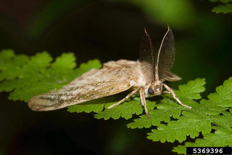
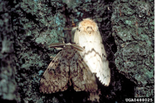
Spongy moths are a species of moth native to Europe and Asia. These moths were introduced to the United States in 1869 and have damaged millions of acres of forests in Virginia and beyond. Because of this, spongy moths are considered an invasive species.
Invasive species: An insect, plant, or animal that is not native (indigenous) to an area that also causes harm to the new environment to which it is introduced.
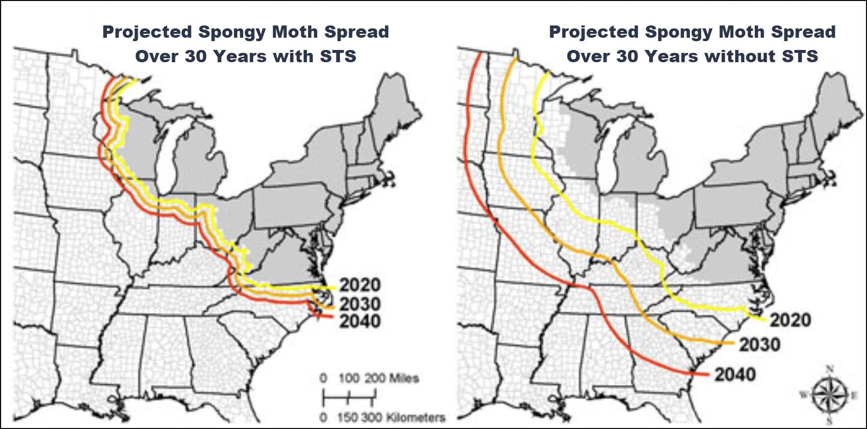
Life Cycle and Slow the Spread
To answer the following, use information form the Slow the Spread (STS) program https://storymaps.arcgis.com/stories/623aebbd564d41668a7db6b97507266f.
- What is the scientific name for spongy moths? ____________________________________________
- How do spongy moths harm the environment? ____________________________________________
- What is the purpose of Slow the Spread? ____________________________________________
- Look at the map in “Quarantined Counties.” Do you live in a quarantined county? ____________________________________________
- How do spongy moths naturally spread? ____________________________________________
- Why is the natural spread of spongy moths very slow? ____________________________________________
- If the natural spread is slow, how do spongy moths spread so quickly? ____________________________________________
- What life stages of the spongy moth are easiest for people to unintentionally spread? ________________________________________
Feeding Preferences
Spongy moth caterpillars love to eat leaves! However, they prefer some species of leaves more than other species. What are some of the most preferred species of leaves that spongy moths like to eat?
- _______________________________
- _______________________________
- _______________________________
- _______________________________
- _______________________________
- _______________________________
The Spread of Spongy Moth Eggs
Spongy moths don’t always lay their eggs on tree trunks or branches—sometimes they lay eggs on items that are then transported by humans! A human can introduce spongy moths to a new area without even realizing it.
Read What to Look for and How to Prevent This Pest on the USDA Spongy Moth website (www.aphis.usda.gov/plant-pests-diseases/spongy-moth) to answer the question below.
Name 6 common items around your home that may spread spongy moth eggs:
- _______________________________
- _______________________________
- _______________________________
- _______________________________
- _______________________________
- _______________________________
Up Next: We’ll imagine a trackable GeoCoin is a mass of spongy moth eggs attached to an unsuspecting hiker’s backpack. We’ll track the egg mass to see where it goes and what impacts it might have as it travels!
Spongy Moth Data Collection
You or someone else in your group should have dropped off a geocoin in a geocache a while ago (See Virginia Geocoin Adventure: Getting Started Manual if these terms sound unfamiliar). Now, we can use your GeoCoin’s log information to explore spongy moth infestations. We will imagine that your Virginia GeoCoin is a mass of spongy moth eggs. We will track the location of the spongy moth egg mass as it moves from place to place (via geocaches) and get an idea of how the spread of the spongy moth could impact that environment.
Note to Leaders: You’ll want to make sure that your Geocoin has traveled to at least 3 (hopefully more) different places before starting this activity. If it has not, then you can always select a different geocoin to complete this exercise. You can conduct a search for Trackable Geocoins on www.geocaching.com/play, and under the ‘Play’ menu, select ‘Trackables.’ You can search for a “Trackable by name” and enter ‘VirginiaView’ (for a listing of all VirginiaView Geocoins), ‘Map@syst’ (for a listing of all Map@syst Geocoins), ‘4H’ (for a listing of all 4H geocoins), or any other geocoin name that you might be familiar with! You can sort these lists by distance traveled (number of miles)! If you have not dropped off trackable Geocoin, then you can use an existing trackable item that is already in circulation.
Required Software: You will also want to ensure Google Earth Pro for desktop has been installed before beginning the activity. You can download the desktop version at www.google.com/earth/about/versions/. For a primer on how to navigate Google Earth, download the Google Earth tutorial from virginiaview.cnre.vt.edu/tutorials/.
Note to Leaders: The Appendix A table is located at the end of the Spongy Moth section. However, for a downloadable version of the Appendix A table, visit the Google Spreadsheets link and create as many copies as you need. Also, feel free to modify the spreadsheet to fit your class needs after downloading a copy. docs.google.com/spreadsheets/d/1uQ8qxJ9De3wZxOwoBTHfs1TMVEdIMXTG-p4n2LxEjMw/edit?usp=drive_link
Let’s Get Started!
- Log in to www.geocaching.com/play with the account you used when you dropped off the geocoin.
- From the ‘Play’ dropdown menu, select ‘Trackables’ (Figure 2.4).
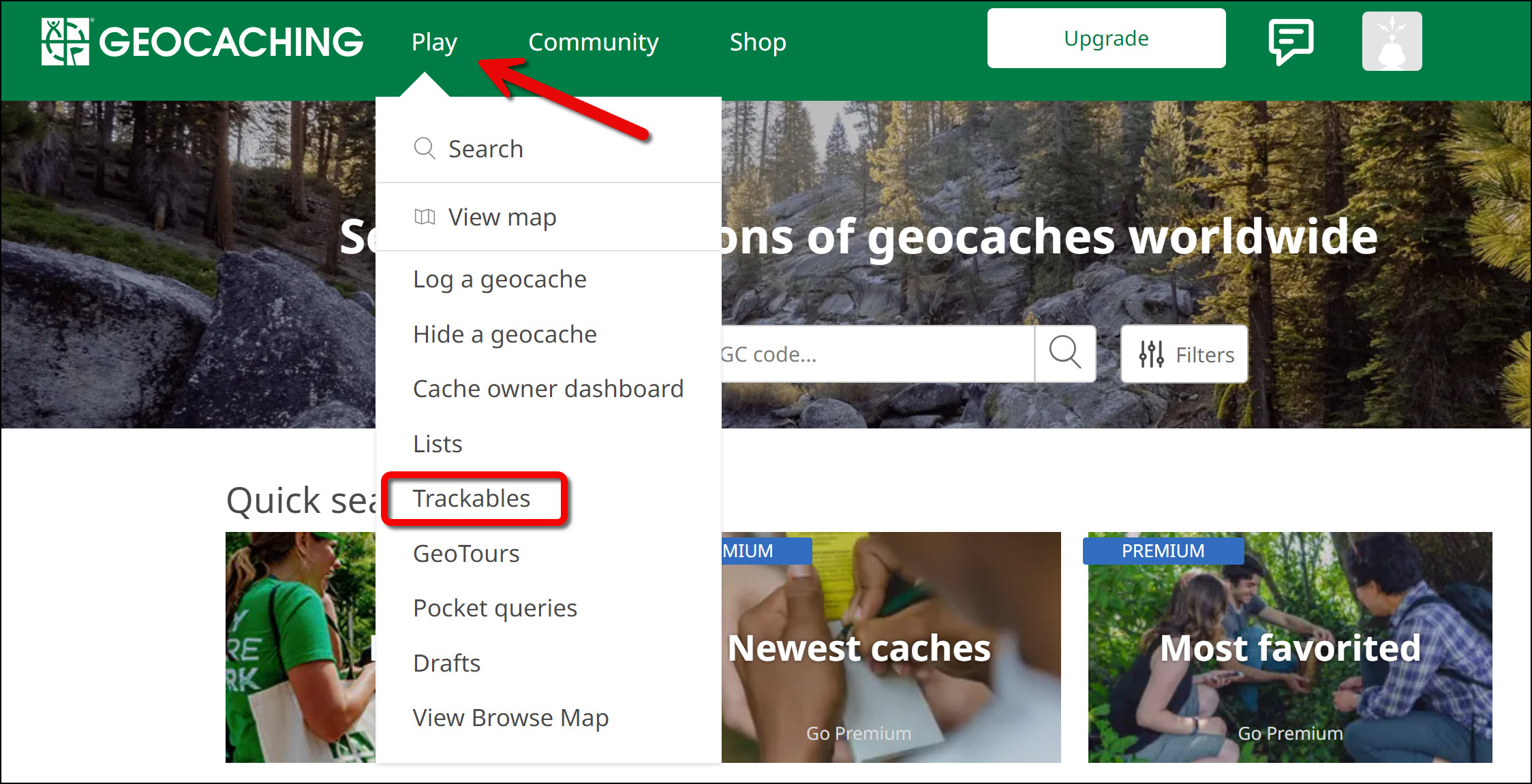
Figure 2.4: Arrow pointing to the ‘Play’ button with its dropdown menu open. A rectangle enclosed on the ‘Trackables’ button. - Enter the tracking code printed on the trackable (ex: XX234XX). Note: Once the secret tracking code is entered, a ‘nickname number’ will appear on the webpage to reference the geocoin. The nickname number is okay to share with others.
- Scroll down to the bottom of the page to see ‘Tracking History’ (Figure 2.5). Each entry in the log represents one move of a spongy moth egg mass by an unsuspecting hiker.
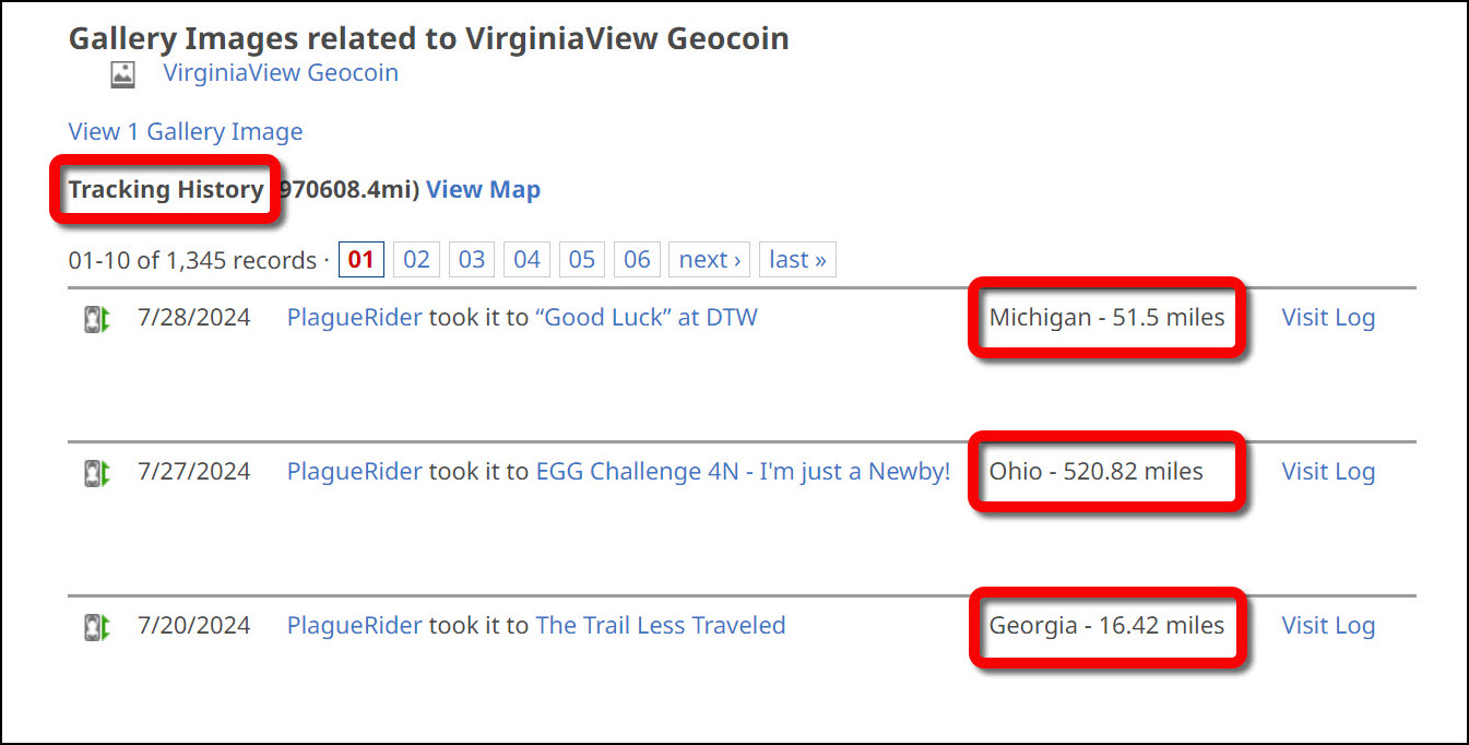
Figure 2.5: Lower section of the Geocoin’s log page displaying the Tracking History section with location and distance highlighted. - Complete columns A, B, and C in the chart (located in Appendix A) by using the information on your geocoin’s tracking history. As shown in Figure 2.5, only use the log entries that have a distance traveled shown in the third column.
- Now we will explore a bit more about the spongy moth movements by using Google Earth. We want to think about what impacts our moth egg mass might have at each stop
- From the geocoin’s log page, scroll up and click on ‘View in Google Earth’ under the Trackable Options menu (Figure 2.6). This will generate a KML file for you to download to your computer. Note: Ensure Google Earth Pro for desktop is installed before clicking ‘View in Google Earth.’ You can install the application from www.google.com/earth/about/versions/.
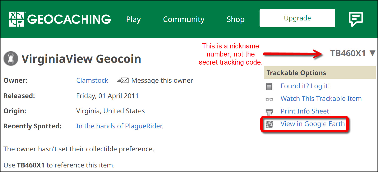
Figure 2.6: Upper section of the Geocoin’s log page displaying where to find the ‘View in Google Earth’ link to download the geocoin’s KML file. - After downloading the KML file to your computer, double click on the file to open it with Google Earth Pro for desktop. You should now see yellow tracks on the map and tracks for your geocoin listed on the left-hand menu. Be sure that the ‘Borders and Labels’ layer is turned on (Figure 2.7). Hint: Turn off the ‘Roads’ layer to better see the geocoin’s tracks.
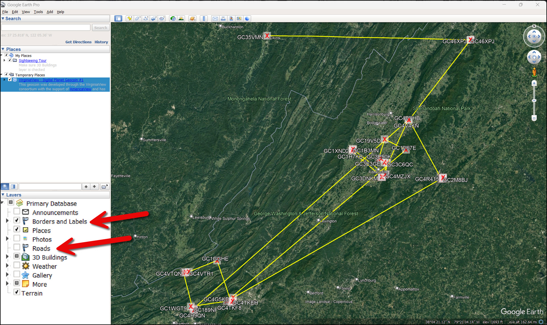
Figure 2.7: Google Earth Pro desktop software displaying yellow tracks that represent the Geocoin’s travel history. Arrows point to the checked ‘Borders and Labels’ layer and the unchecked ‘Roads’ layer. - For each stop on the geocoin’s journey, zoom in and explore the area. By viewing the aerial photography, estimate the major land use or land cover in the area. Some areas may be more difficult than others, depending on the information available in Google Earth. Explore other menu options and additions in Google Earth to help you come up with your best estimate of the major land use and land cover for each geocoin stop.
- We know that most of the moth larvae only spread about 600 feet from the nest site, but some travel up to a mile by wind currents. Use the ruler tool from the top menu bar and set the units to feet or miles to help you estimate a 600–foot and 1-mile radius. Then, click the Circle tab to draw a circle around the geocoin using the 600-foot and 1-mile radius guidelines (Figure 2.8 and Figure 2.9). Record your findings in columns D and E on the chart in Appendix A.
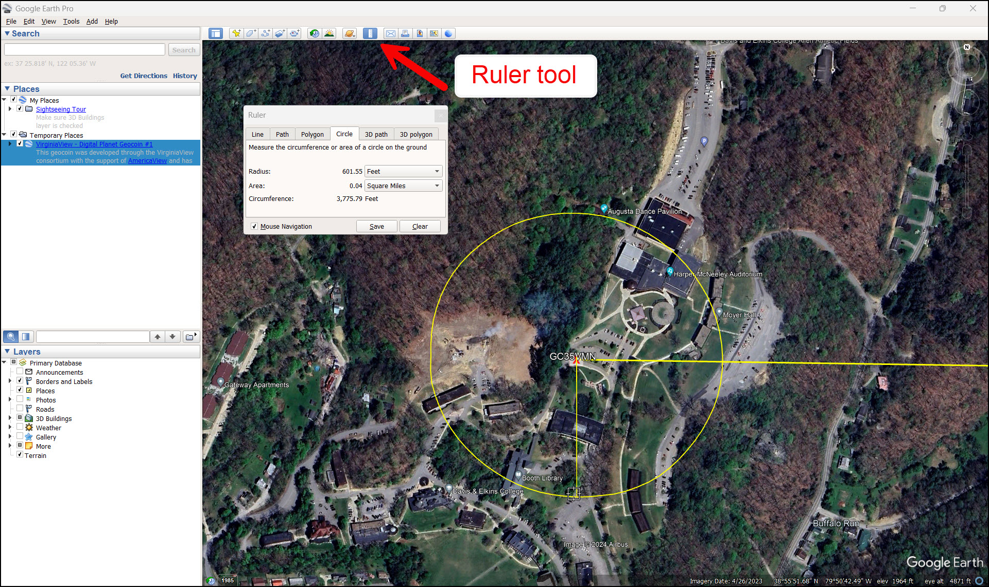
Figure 2.8: Using the Circle Ruler tool to estimate a 600-foot radius from the Geocoin’s location. The land cover in this area includes forest, disturbed/bare ground for construction, and developed land for academic uses. 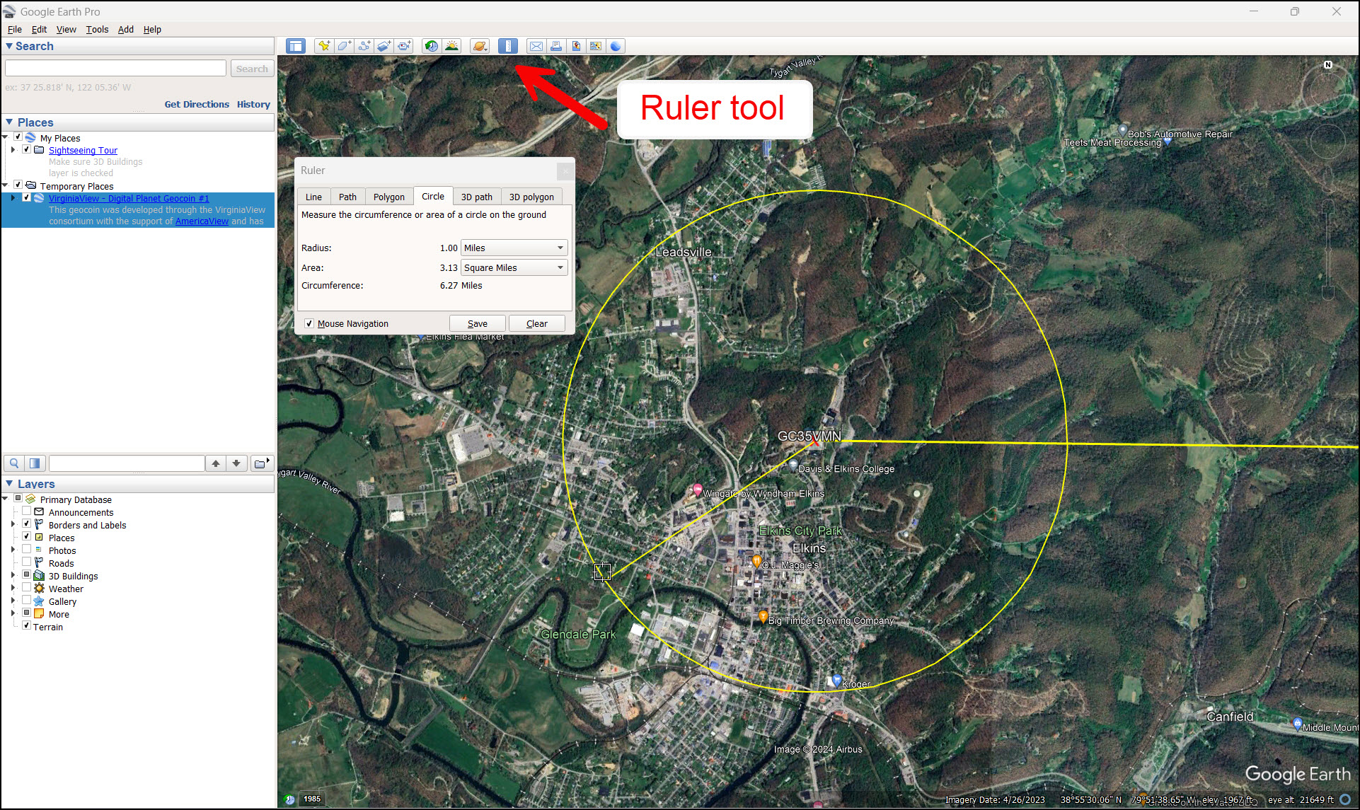
Figure 2.9: The same point as Figure 2.8 with a 1-mile length radius using the Circle Ruler tool. The land cover is about 40% forested and 60% commercial and industrial. - Optional: For each stop your geocoin made, determine how it got there from the previous stop. There may be more than one mode of travel (for example: plane, car, train, hiker, biker, grills, or patio furniture moved from place to place, etc….). Use the details on the geocoin log as well as Google Earth to figure out how the coin traveled between places. Record your answer in column F on the chart in Appendix A. Using the information you learned about spongy moths in the background information and the data you just collected on land use and land cover in Google Earth, decide, for each geocoin stop, if the area would be susceptible to a spongy moth outbreak from the egg mass that moved there. Record your answer in column G on the chart in Appendix A.
- What was the total distance traveled by your spongy moth eggs (geocoin) so far? Hint: this is shown on your geocoin’s log page on geocaching.com.
- What was the farthest the egg mass traveled between two points?
- What factors did you consider when deciding if an area was likely to have a spongy moth infestation from the eggs?
- How might topography impact the spread of the Spongy moth?
- How would the land use / land cover affect the susceptibility of an area?
- How do the travel patterns of humans affect the spread of the spongy moth (and other invasive species)?
- Suppose you live in an area that does not currently have a spongy moth infestation problem but has tree species that are susceptible. How could you stop or slow the spread of spongy moths to your area?
Appendix A. Table to record data collected in exercise
|
(A) Date |
(B) Location (place name or landmark near the cache) |
(C) Distance traveled since last log (in miles) |
(D) Predominant land cover in a 600-foot radius |
(E) Predominant land cover in a 1-mile radius |
(F) Possible modes of travel |
(G) Area susceptible to spongy moth infestation? |
|
|
|
|
|
|
|
|
|
|
|
|
|
|
|
|
|
|
|
|
|
|
|
|
|
|
|
|
|
|
|
|
|
|
|
|
|
|
|
|
|
|
|
|
|
|
|
|
|
|
|
|
|
|
|
|
| Notes: |